Engineering geology
The application of education and experience in geology and other geosciences to solve geological problems posed by civil engineering works. The branches of the geosciences most applicable are surficial geology, petrofabrics, rock and soil mechanics, geohydrology, and geophysics, particularly exploration geophysics and earthquake seismology. This article discusses some of the practical aspects of engineering geology.
Terminology
The terms engineering geology and environmental geology often seem to be used interchangeably. Specifically, environmental geology is the application of engineering geology in the solution of urban problems; in the prediction and mitigation of natural hazards such as earthquakes, landslides, and subsidence; and in solving problems inherent in disposal of dangerous wastes and in reclaiming mined lands.
Another relevant term is geotechnics, the combination of pertinent geoscience elements with civil engineering elements to formulate the civil engineering system that has the optimal interaction with the natural environment.
Engineering properties of rock
The civil engineer and the engineering geologist consider most hard and compact natural materials of the earth crust as rock, and their derivatives, formed mostly by weathering processes, as soil. A number of useful soil classification systems exist. Because of the lack of a rock classification system suitable for civil engineering purposes, most engineering geology reports use generic classification systems modified by appropriate rock-property adjectives. See also: Rock; Rock mechanics; Soil mechanics
Rock sampling
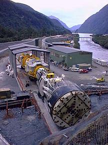
The properties of a rock element can be determined by tests on cores obtained from boreholes. These holes are made by one or a combination of the following basic types of drills: the rotary or core drill, the cable-tool or churn drill, and the auger. The rotary type generally is used to obtain rock cores. The rotary rig has a motor or engine (gasoline, diesel, electric, or compressed air) that drives a drill head that rotates a drill rod (a thick-walled hollow pipe) fastened to a core barrel with a bit at its end. Downward pressure on the bit is created by hydraulic pressure in the drill head. Water or air is used to remove the rock that is comminuted (chipped or ground) by the diamonds or hard-metal alloy used to face the bit. The core barrel may be in one piece or have one or two inner metal tubes to facilitate recovery of soft or badly broken rock (double-tube and triple-tube core barrels). The churn-type drill may be used to extend the hole through the soil overlying the rock, to chop through boulders, occasionally to deepen a hole in rock when core is not required or to obtain drive samples of the overburden soils. When the rock is too broken to support itself, casing (steel pipe) is driven or drilled through the broken zone. Drill rigs range in size from those mounted on the rear of large multiwheel trucks to small, portable ones that can be packed to the investigation site on a person's back or parachuted from a small plane. See also: Drilling, geotechnical
The rock properties most useful to the engineering geologist are compressive and triaxial shear strengths, permeability, Young's modulus of elasticity, erodability under water action, and density (in pounds per cubic foot, or pcf).
Compressive strength
The compressive (crushing) strength of rock generally is measured in pounds per square inch or kilograms per square centimeter. It is the amount of stress required to fracture a sample unconfined on the sides and loaded on the ends (Fig. 1). If the load P of 40,000 lb is applied to a sample with a diameter of 2 in. (3.14 in.2), the compressive stress is 40,000 ÷ 3.14 = 12,738 lb/in.2 (177,920 N ÷ 0.00203 m2 = 87,645 kN/m2). If this load breaks the sample, the ultimate compressive strength equals the compressive stress acting at the moment of failure, in this case 12,738 lb/in.2. The test samples generally are cylindrical rock cores that have a length-to-diameter ratio (L/D) of about 2. The wide variety of classification systems used for rock results in a wide variation in compressive strengths for rocks having the same geologic name. The table gives a statistical evaluation of the compressive strengths of several rocks commonly encountered in engineering geology.
Fig. 1 Unconfined compression test. (a) Shear failure, showing failure planes QS. (b) Tension failure. (After D. P. Krynine and W. R. Judd,Principles of Engineering Geology and Geotechnics, McGraw-Hill, 1957)

Most laboratory tests show that an increase in moisture in rock causes a decrease in its compressive strength and elastic modulus; what is not generally known, however, is that the reverse situation shown in Fig. 2 has been encountered in certain types of volcanic rocks. In sedimentary rock the compressive strength is strongly dependent upon the quality of the cement that bonds the mineral grains together (for example, clay cement gives low strength) and upon the quantity of cement (a rock may have only a small amount of cement, and despite a strong bond between the grains, the strength is directly related to the inherent strength of the grains). Strength test results are adversely affected by microfractures that may be present in the sample prior to testing, particularly if the microfractures are oriented parallel to the potential failure planes.
Fig. 2 Increase in Young's modulus caused by saturation of dacite porphyry. (After J. R. Ege and R. B. Johnson, Consolidated tables of physical properties of rock samples from area 401, Nevada Test Site, U.S. Geol. Surv. Tech. Letter Pluto-21, 1962)

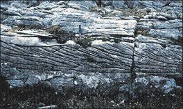
The value of compressive strength to be used in an engineering design must be related to the direction of the structure's load and the orientation of the bedding, discontinuities, and structural weaknesses in the foundation rock. This relationship is important because the highest compressive strength usually is obtained when the compressive stress is normal to the bedding. Conversely, the highest Young's modulus of elasticity (E) usually results when the compressive stress parallels the bedding. When these strength and elastic properties apparently are not affected by the direction of applied load, the rock is described as isotropic; if load applied parallel to the bedding provides physical property data that are significantly different than those obtained when the load is applied normal (perpendicular) to the bedding, the rock is anisotropic or aeolotropic. If the physical components of the rock element or rock system have equal dimensions and equal fabric relationships, the rock is homogeneous; significant variance in these relationships results in a heterogeneous rock. Most rocks encountered in foundations and underground works are anisotropic and heterogeneous.
Shear in rocks
Shearing stresses tend to separate portions of the rock (or soil) mass. Faults and folds are examples of shear failures in nature. In engineering structures, every compression is accompanied by shear stresses. For example, an arch dam compresses the abutment rock and, if the latter is intersected by fissures or weak zones, it may fail in shear with a resulting tensile stress in the dam concrete that may rupture the concrete. The application of loads over long periods of time on most rocks will cause them to creep or even to flow like a dense fluid (plastic flow). See also: Structural geology
Ambient stress
This type of stress in a rock system is actually potential energy, probably created by ancient natural forces, recent seismic activity, or nearby human-caused disturbances. Ambient (residual, stored, or primary) stress may remain in rock long after the disturbance is removed. An excavation, such as a tunnel or quarry, will relieve the ambient stress by providing room for displacement of the rock, and thus the potential energy is converted to kinetic energy. In tunnels and quarries, the release of this energy can cause spalling, the slow outward separation of rock slabs from the rock massif; when this movement is rapid or explosive, a rock burst occurs. The latter is a different phenomenon from a rock bump, which is a rapid upward movement of a large portion of a rock system and, in a tunnel, can have sufficient force to flatten a steel mine car against the roof or break the legs of a person standing on the floor when the bump occurs. See also: Rock burst; Underground mining
One of two fundamental principles generally is used to predict the possible rock load on a tunnel roof, steel, or timber supports, or a concrete or steel lining: (1) The weight of the burden (the rock and soil mass between the roof and the ground surface) and its shear strength control the load, and therefore the resultant stresses are depth-dependent, or (2) the shear strength of the rock system and the ambient stresses control the stress distribution, so the resultant loading is only indirectly dependent upon depth. The excavation process can cause rapid redistribution of these stresses to produce high loads upon supports some distance from the newly excavated face in the tunnel. The geometry and span of the opening also influence the stress distribution. Lined tunnels can be designed so that the reinforced concrete or steel lining will have to carry only a portion of the ambient or burden stresses. See also: Tunnel
Construction material
Rock as a construction material is used in the form of dimension, crushed, or broken stone. Broken stone is placed as riprap on slopes of earth dams, canals, and river banks to protect them against water action. Also, it is used as the core and armor stone for breakwater structures. For all such uses, the stone should have high density (±165 lb/ft3 or 2650 kg/m3), be insoluble in water, and be relatively nonporous to resist cavitation. Dimension stone (granite, limestone, sandstone, and some basalts) is quarried and sawed into blocks of a shape and size suitable for facing buildings or for interior decorative panels. For exterior use, dimension stone preferably should be isotropic (in physical properties), have a low coefficient of expansion when subjected to temperature changes, and be resistant to deleterious chemicals in the atmosphere (such as sulfuric acid). Crushed stone (primarily limestone but also some basalt, granite, sandstone, and quartzite) is used as aggregate in concrete and in bituminous surfaces for highways, as a base course or embankment material for highways, and for railroad ballast (to support the ties). When used in highway construction, the crushed stone should be resistant to abrasion as fine stone dust reduces the permeability of the stone layer; the roadway then is more susceptible to settling and heaving caused by freezing and thawing of water in the embankment. Concrete aggregate must be free of deleterious material such as opal and chalcedony; volcanic rocks containing glass, devitrified glass, and tridymite; quartz with microfractures; phyllites containing hydromica (illites); and other rocks containing free silica (SiO2). These materials will react chemically with the cement in concrete and release sodium and potassium oxides (alkalies) or silica gels. Preliminary petrographic analyses of the aggregate and chemical analysis of the cement can indicate the possibility of alkali reactions and thus prevent construction difficulties such as expansion, cracking, or a strength decrease of the concrete. See also: Cavitation; Concrete; Petrography; Stone and stone products
Geotechnical significance of soils
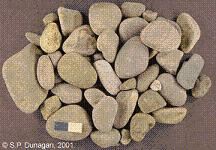
Glacial and alluvial deposits contain heterogeneous mixtures of pervious (sand and gravel) and impervious (clay, silt, and rock flour) soil materials. The pervious materials can be used for highway subgrade, concrete aggregate, and filters and pervious zones in earth embankments. Dam reservoirs may be endangered by the presence of stratified or lenticular bodies of pervious materials or ancient buried river channels filled with pervious material. Deep alluvial deposits in or close to river deltas may contain very soft materials such as organic silt or mud. An unsuitable soil that has been found in dam foundations is open-work gravel. This material may have a good bearing strength because of a natural cement bond between grains, but it is highly pervious because of the almost complete lack of fine soil to fill the voids between the gravel pebbles. See also: Delta; Floodplain
Concrete or earth dams can be built safely on sand foundations if the latter receive special treatment. One requirement is to minimize seepage losses by the construction of cutoff walls (of concrete, compacted clay, or interlocking-steel-sheet piling) or by use of mixed-in-place piles 3 ft (0.9 m) or more in diameter. The latter are constructed by augering to the required depth but not removing any of the sand. At the desired depth, cement grout is pumped through the hollow stem of the auger, which is slowly withdrawn while still rotating; this mixes the grout and the sand into a relatively impervious concrete pile. The cutoff is created by overlapping these augered holes. Some sand foundations may incur excessive consolidation when loaded and then saturated, particularly if there is a vibratory load from heavy machinery or high-velocity water in a spillway. This problem is minimized prior to loading by using a vibrating probe inserted into the sand or vibratory rollers on the sand surface or by removing the sand and then replacing it under vibratory compaction and water sluicing.
Aeolian (windblown) deposits
Loess is a relatively low-density (±0.044 ton/ft3 or 1.4 metric tons/m3) soil composed primarily of silt grains cemented by clay or calcium carbonate. It has a vertical permeability considerably greater than the horizontal. When a loaded loess deposit is wetted, it rapidly consolidates, and the overlaying structure settles. When permanent open excavations (“cuts”) are required for highways or canals through loess, the sides of the cut should be as near vertical as possible: Sloping cuts in loesses will rapidly erode and slide because of the high vertical permeability. To avoid undesirable settlement of earth embankments, the loess is “prewetted” prior to construction by building ponds on the foundation surface. Permanently dry loess is a relatively strong bearing material. Aeolian sand deposits present the problem of stabilization for the continually moving sand. This can be done by planting such vegetation as heather or young pine or by treating it with crude oil. Cuts are traps for moving sand and should be avoided. The failure of Teton Dam in 1976 indicated, among other factors, that when loessial or silty soils are used for core materials in dam embankments, it is important to take special measures to prevent piping of the silts by carefully controlled compaction of the core, by using up- and downstream filters, and by extraordinary treatment of the foundation rock. See also: Loess
Organic deposits
Excessive settlement will occur in structures founded on muskeg terrain. Embankments can be stabilized by good drainage, the avoidance of cuts, and the removal of the organic soil and replacement by sand and gravel or, when removal is uneconomical, displacement of it by the continuous dumping of embankment material upon it. Structures imposing concentrated loads are supported by piling driven through the soft layers into layers with sufficient bearing power. See also: Muskeg; Tundra
Residual soils
These soils are derived from the in-place deterioration of the underlying bedrock. The granular material caused by the in-place disintegration of granite generally is sufficiently thin to cause only nominal problems. However, there are regions (such as California, Australia, and Brazil) where the disintegrated granite (locally termed DG) may be hundreds of feet thick; although it may be competent to support moderate loads, it is unstable in open excavations and is pervious. A thickness of about 200 ft (60 m) of DG and weathered gneiss on the sides of a narrow canyon was a major cause for construction of the Tumut-1 Power Plant (New South Wales) in hard rock some 1200 ft (365 m) underground. Laterite (a red clayey soil) derived from the in-place disintegration of limestone in tropical to semitropical climates is another critical residual soil. It is unstable in open cuts on moderately steep slopes, is compressible under load, and when wet produces a slick surface that is unsatisfactory for vehicular traffic. This soil frequently is encountered in the southeastern United States, southeastern Asia, and South America.
Clays supporting structures may consolidate slowly over a long period of time and cause structural damage. When clay containing montmorillonite is constantly dried and rewetted by climatic or drainage processes, it alternately contracts and expands. During the drying cycle, extensive networks of fissures are formed that facilitate the rapid introduction of water during a rainfall. This cyclic volume change of the clay can produce uplift forces on structures placed upon the clay or compressive and uplift forces on walls of structures placed within the clay. These forces have been known to rupture concrete walls containing 10.75-in.-diameter (19-mm) steel reinforcement bars. A thixotropic or “quick” clay has a unique lattice structure that causes the clay to become fluid when subjected to vibratory forces. Various techniques are used to improve the foundation characteristics of critical types of clay: (1) electroosmosis that uses electricity to force redistribution of water molecules and subsequent hardening of the clay around the anodes inserted in the foundation; (2) provision of adequate space beneath a foundation slab or beam so the clay can expand upward and not lift the structure; (3) belling, or increasing in size, of the diameter of the lower end of concrete piling so the pile will withstand uplift forces imposed by clay layers around the upper part of the pile; (4) treatment of the pile surface with a frictionless coating (such as poly(tetrafluoroethylene) or a loose wrapping of asphalt-impregnated paper) so the upward-moving clay cannot adhere to the pile; (5) sufficient drainage around the structure to prevent moisture from contacting the clay; and (6) replacement of the clay by a satisfactory foundation material. Where none of these solutions is feasible, the structure then must be relocated to a satisfactory site or designed so it can withstand uplift or compressive forces without extensive damage. See also: Clay
Silt may settle rapidly under a load or offer a “quick” condition when saturated. For supporting some structures (such as residences), the bearing capacity of silts and fine sands can be improved by intermixing them with certain chemicals that will cause the mixture to “set” or harden when exposed to air or moisture; some of the chemicals used are sodium silicate with the later application of calcium chloride, bituminous compounds, phenolic resins, or special cements (to form “soil cement”). The last mixture has been used for surfacing secondary roads, for jungle runways in Vietnam, and as a substitute for riprap of earth dams. Some types of silt foundations can be improved by pumping into them soil-cement or clay mixtures under sufficient pressures to create large bulbs of compacted silt around the pumped area.
Geotechnical investigation
For engineering projects, these investigations may include preliminary studies, preconstruction or design investigations, consultation during construction, and the maintenance of the completed structure.
Preliminary studies
These are made to select the best location for a project and to aid in formulating the preliminary designs for the structures. The first step in the study is a search for pertinent published material in libraries, state and federal agencies, private companies, and university theses. Regional, and occasionally detailed reports on local geology, including geologic maps, are available in publications of the U.S. Geological Survey; topographic maps are available from that agency and from the U.S. Army Map Service. Oil companies occasionally will release the geologic logs of any drilling they may have done in a project area. Air photos and other remote sensing techniques such as pulsed or side-looking radar or false color can be used to supplement map information (or may be the only surficial information readily available). The U.S. Geological Survey maintains a current index map of the air-photo coverage of the United States. The photos are available from that agency, the U.S. Forest Service, the Natural Resources Conservation Service, and commercial air-photo companies; for some projects, the military agencies will provide air-photo coverage. The topographic maps and air photos can be used to study rock outcrop and drainage patterns, landforms, geologic structures, the nature of soil and vegetation, moisture conditions, and land use by humans (cultural features). Airborne geophysical techniques using magnetometers or gravimeters also may be useful to delineate surface and subsurface geologic conditions. See also: Aerial photography; Literature of science and technology; Remote sensing; Topographic surveying and mapping
Field reconnaissance may include the collection of rock and soil specimens; inspection of road cuts and other excavations; inspection of the condition of nearby engineering structures such as bridges, pavements, and buildings; and location of sources of construction material. Aerial reconnaissance is essential at this stage and can be performed best in helicopters and second-best in slow-flying small planes.
Preconstruction
Surface and subsurface investigations are required prior to design and construction. Surface studies include the preparation of a detailed map of surficial geology, hydrologic features, and well-defined landforms. For dam projects, a small-scale geologic map (for example, 1:5000) is made of the reservoir area and any adjacent areas that may be directly influenced by the project; in addition, a large-scale geologic map (for example, 1:500) is required of the specific sites of the main structures (the dam, spillway, power plant, tunnels, and so on). [This preferred means of designating map scales can be used for either customary or metric units. It means 1 unit of measurement on the map is equal to 5000 similar units on the ground; for example, 1 cm measured on the map is equal to 5000 cm measured on the ground.] These maps can be compiled by a combination of field survey methods and aerial mapping procedures. They should have a grid system (coordinates) and show the proposed locations for subsurface investigations.
Subsurface investigations are required to confirm and amplify the surficial geologic data. These may include test pits, trenches, short tunnels (drifts or adits), and the drilling of vertical, horizontal, or oblique (angle) boreholes. Geologic data obtained by these direct methods can be supplemented by indirect or interpreted data obtained by geophysical methods on the surface or in subsurface holes and by installation of special instruments to measure strain or deformation in a borehole or tunnel.
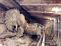
The geology disclosed by subsurface investigations is “logged” on appropriate forms. Tunnel logs display visual measurements of features and joint orientations (strike and dip); rock names and a description of their estimated engineering properties; alteration, layering, and other geologic defects; the location and amount of water or gas inflow; the size and shape of blocks caused by fracturing or jointing and the width of separation or the filling material between blocks; and the irregularities in the shape of the tunnel caused by the displacement of blocks during or after excavation (rock falls, rock bursts, chimneying, and overbreakage). Geophysical seismic methods may be used to define the thickness of loosened rock around the tunnel; geoacoustical techniques that detect increases in microseismic noise during tunneling may be used to determine if the excavation is causing excessive loosening in the tunnel rock. This detection of “subaudible rock noise” occasionally is used to detect the potential movement of rock slopes in open excavations.
The borehole data can be logged on a form such as shown in Fig. 3. These data can be obtained by direct examination of the core, by visual inspection of the interior of the borehole using a borehole camera (a specially made television camera) or a stratoscope (a periscopelike device), or by geophysical techniques. Direct viewing of the interior of the hole is the only positive method of determining the in-place orientation and characteristics of separations and of layering in the rock system. The geophysical techniques include use of gamma-gamma logging that evaluates the density of the rock surrounding the borehole or at depths as great as 150 ft (45 m) beneath the gamma probe; neutron logging to determine the moisture content of the rock system by measuring the depth of penetration of the neutrons; traversing the borehole with a sonic logger that, by calibration, measures differences in the velocity of wave propagation in different strata (and thus can determine in place Young's modulus of elasticity and the thickness of each stratum encountered by the borehole); and electric logging that uses differences in the electrical resistivity of different strata to define their porosity, moisture content, and thickness.
Occasionally a hole is drilled through a talus deposit containing the same type of rock as the underlying rock in place (bedrock). Because of the similarity in rock types, the talus-bedrock contact sometimes is best identified by determining the orientation of the remnant magnetism in the core: the magnetic lines in the core will have a regular orientation, but the talus magnetism will have random directions. This method is useful only in rocks that contain appreciable remnant magnetism such as some basalts.
Geophysical seismic or electrical resistivity methods also can be used on the ground surface to define the approximate depth of bedrock or various rock layers. The results require verification by occasional boreholes, but this is an inexpensive and satisfactory technique for planning and design investigations. The seismic methods are not useful when it is necessary to locate soft strata (wherein the seismic waves travel at relatively low velocity) that are overlain by hard strata (that have higher wave velocity); the latter conceal and block the signal from the soft strata. Also, difficulties may occur when the strata to be located are overlain by soil containing numerous large boulders composed of rock having higher velocities than the surrounding soil, or when the soil is very compact (such as glacial till) because its velocity characteristics may resemble those of the underlying bedrock. Another problem is that the seismic method seldom can identify narrow and steep declivities in the underlying hard rock (because of improper reflection of the waves).
Construction
Geotechnical supervision is desirable during construction in or on earth media. The engineering geologist must give advice and keep a record of all geotechnical difficulties encountered during the construction and of all geological features disclosed by excavations. During the operation and maintenance of a completed project the services of the engineering geologist often are required to determine causes and assist in the preparation of corrective measures for cracks in linings of water tunnels, excessive settlement of structures, undesirable seepage in the foundations of dams, slides in canal and other open excavations, overturning of steel transmission-line towers owing to a foundation failure, and rock falls onto hydroelectric power plants at the base of steep canyon walls. The engineering geologist also is considered an important member of the team assigned to the task of assessing the safety of existing dams as now required by federal legislation.
Legal aspects
An important consideration for the engineering geologist is the possibility of a contractor making legal claims for damages, purportedly because of unforeseen geologic conditions (generally referred to legally as charged conditions) encountered during construction. Legal support for such claims can be diminished if the engineering geologist supplies accurate and detailed geologic information in the specification and drawings used for bidding purposes. These documents should not contain assumptions about the geological conditions (for a proposed structure), but they should show all tangible geologic data obtained during the investigation for the project: for example, an accurate log of all boreholes and drifts and a drawing showing the boundaries of the outcrops of all geological formations in the project area. The engineering geologist should have sufficient experience with design and construction procedures to formulate an investigation program that results in a minimum of subsequent uncertainties by a contractor. Numerous uncertainties about the geologic conditions not only can result in increased claims but also may cause a contractor to submit a higher bid (in order to minimize risks) than if detailed geologic information were available.
Special geotechnical problems
In arctic zones, structures built on permafrost may be heaved or may cause thawing and subsequent disastrous settlement. The growth of permafrost upward into earth dams seriously affects their stability and permeability characteristics. Obtaining natural construction materials in permafrosted areas requires thawing of the borrow area to permit efficient excavation; once excavated, the material must be protected against refreezing prior to placement in the structures. Permafrost in rock seldom will cause foundation difficulties. In planning reservoirs, it is essential to evaluate their watertightness, particularly in areas containing carbonate or sulfate rock formation or lava flows. These formations frequently contain extensive systems of caverns and channels that may or may not be filled with claylike material or water. Where extensive openings occur, grouting with cement slurry or chemicals can be used as a sealant; however, as demonstrated by the 1976 failure of the Teton Dam, such measures are not always successful. Sedimentation studies are required for the design of efficient harbors or reservoirs because soil carried by moving water will settle and block or fill these structures. In areas with known earthquake activity, structural design requires knowledge of the intensity and magnitude of earthquake forces. The prevention and rehabilitation of slides (landslides) in steep natural slopes and in excavations are important considerations in many construction projects and are particularly important in planning reservoirs, as was disastrously proved by the Vaiont Dam catastrophe in 1963. See also: Earthquake engineering; Permafrost
Geohydrologic problems
In the foundation material under a structure, water can occur in the form of pore water locked into the interstices or pores of the soil or rock, as free water that is moving through openings in the earth media, or as included water that is a constituent or chemically bound part of the soil or rock. When the structure load compresses the foundation material, the resulting compressive forces on the pore water can produce undesirable uplift pressures on the base of the structure. Free water is indicative of the permeability of the foundation material and possible excessive water loss (from a reservoir, canal, or tunnel); uplift on the structure because of an increase in hydrostatic head (caused by a reservoir or the like); or piping, which is the removal of particles of the natural material by flowing water with a consequent unfilled opening that weakens the foundation and increases seepage losses.
The possibility of excessive seepage or piping can be learned by appropriate tests during the boring program. For example, water pressure can be placed on each 5-ft (2-m) section of a borehole, after the core is removed, and any resulting water loss can be measured. The water pressure is maintained within the 5-ft section by placing an expandable rubber ring (packer) around the drill pipe at the top of the test section and then sealing off the section by using mechanical or hydraulic pressure on the pipe to force expansion of the packer. When only one packer is used, because it is desired to test only the section of hole beneath it, it is a “single-packer” test. In a double-packer test, a segment of hole is isolated for pressure testing by placing packers at the top and the bottom of the test section. The best information on the permeability characteristics of the rock can be obtained by the use of three or more increments of increasing and then decreasing water pressure for each tested length of hole. If the water loss continues to increase when the pressure is decreased, piping of the rock or filling material in fractures may be occurring or fractures are widening or forming. The water-pressure test can be supplemented by a groutability test in the same borehole. This test is performed in the same way as the water test except, instead of water, a mixture of cement, sand, and water (cement grout) or a phenolic resin (chemical grout) is pumped under pressure into the test section. The resulting information is used to design cutoff walls and grout curtains for dams. The pressures used in water-pressure or grouting tests should not exceed the pressure exerted by the weight of the burden between the ground surface and the top of the test section. Excessive test pressure can cause uplift in the rock, and the resulting test data will be misleading.
Included or pore water generally is determined by laboratory tests on cores; these are shipped from the borehole to the laboratory in relatively impervious containers that resist loss of moisture from the core. The cores with their natural moisture content are weighed when received and then dried in a vacuum oven at about 110°F (45°C) until their dry weight stabilizes. The percentage of pore water (by dry weight) is (wet weight − dry weight) × 100 ÷ dry weight.
Temperatures up to 200°F (about 90°C) can be used for more rapid drying, provided the dried specimens are not to be used for strength or elastic property determinations. (High temperatures can significantly affect the strength because the heat apparently causes internal stresses that disturb the rock fabric or change the chemical composition of the rock by evaporation of the included moisture.)
Protective construction
Civilian and military structures may be designed to minimize the effects of nuclear explosions. The most effective protection is to place the facility in a hardened underground excavation. A hardened facility, including the excavation and its contents, is able to withstand the effects generated by a specified size of nuclear weapon. These effects include the amount of displacement, acceleration, and particle velocity that occurs in the earth media and the adjacent structure. Desirable depths and configurations for hardened facilities are highly dependent upon the shock-wave characteristics of the surrounding earth media, for example, the type of rock, discontinuities in the rock system, free water, and geologic structure. Therefore, prior to the design and construction of such facilities, extensive geotechnical field and laboratory tests are performed, including an accurate geologic map of the surface and of the underground environment that will be affected by the explosion. The map should show the precise location and orientation of all geologic defects that would influence the wave path, such as joints, fractures, and layers of alternately hard and soft rock. See also: Explosive; Nuclear explosion
Application of nuclear energy
The use of nuclear energy for the efficient construction of civil engineering projects has been investigated in the Plowshare Program. Examples include rapid excavation, increasing production of natural gas by opening fractures in the reservoir rock, expediting production of low-grade copper ore by causing extensive fracturing and possible concentration of the ore, and by the underground “cracking” of oil shale. The production of electrical energy by nuclear fission requires engineering geology inputs during the planning and design of the power plant; for example, a major question to be answered is the presence or absence of faults and an estimate of when the last movement on the fault occurred. This question of “active” faults also is of increasing concern in the siting of dams.
Waste disposal
Another geotechnical problem occurs in the use of nuclear energy for generation of power or radioisotopes: safe disposal of the radioactive waste products. These products can be mixed with concrete and buried in the ground or ocean, but geohydrologic or oceanographic conditions must not be conducive to the deterioration of the concrete. One proposed solution is to excavate large caverns in rock or salt a thousand or more meters deep; however, such a solution must consider possible contamination of ground water in the event that the waste products' containers leak. The disposal of toxic chemical or biological products in deep wells no longer is considered safe.
- F. G. Bell, Engineering Properties of Soil and Rocks, 4th ed., 2000
- B. M. Das, Principles of Geotechnical Engineering, 5th ed., 2001
- R. E. Goodman, Engineering Geology: Rock in Engineering Construction, 1993
- M. E. Harr, Groundwater and Seepage, 1992
- R. B. Johnson and J. V. DeGraff, Principles of Engineering Geology, 1989
- R. F. Leggett and A. W. Hatheway, Geology and Engineering, 3d ed., 1988
- R. F. Legget and P. K. Karrow, Handbook of Geology in Civil Engineering, 3d ed., 1982
- P. H. Rahn, Engineering Geology: An Environmental Approach, 2d ed., 1996
- Q. Zaruba, Landslides and Their Control, 2d ed., 1982
زمین شناسی مهندسی-زمین شناسی مهندسی-زمین شناسی مهندسی-زمین شناسی مهندسی-زمین شناسی مهندسی-زمین شناسی مهندسی-زمین شناسی مهندسی-زمین شناسی مهندسی
زمین شناسی مهندسی-زمین شناسی مهندسی-زمین شناسی مهندسی-زمین شناسی مهندسی-زمین شناسی مهندسی-زمین شناسی مهندسی-زمین شناسی مهندسی-زمین شناسی مهندسیزمین شناسی مهندسی-زمین شناسی مهندسی-زمین شناسی مهندسی-زمین شناسی مهندسی-زمین شناسی مهندسی-زمین شناسی مهندسی-زمین شناسی مهندسی-زمین شناسی مهندسیزمین شناسی مهندسی-زمین شناسی مهندسی-زمین شناسی مهندسی-زمین شناسی مهندسی-زمین شناسی مهندسی-زمین شناسی مهندسی-زمین شناسی مهندسی-زمین شناسی مهندسیزمین شناسی مهندسی-زمین شناسی مهندسی-زمین شناسی مهندسی-زمین شناسی مهندسی-زمین شناسی مهندسی-زمین شناسی مهندسی-زمین شناسی مهندسی-زمین شناسی مهندسیزمین شناسی مهندسی-زمین شناسی مهندسی-زمین شناسی مهندسی-زمین شناسی مهندسی-زمین شناسی مهندسی-زمین شناسی مهندسی-زمین شناسی مهندسی-زمین شناسی مهندسیزمین شناسی مهندسی-زمین شناسی مهندسی-زمین شناسی مهندسی-زمین شناسی مهندسی-زمین شناسی مهندسی-زمین شناسی مهندسی-زمین شناسی مهندسی-زمین شناسی مهندسیزمین شناسی مهندسی-زمین شناسی مهندسی-زمین شناسی مهندسی-زمین شناسی مهندسی-زمین شناسی مهندسی-زمین شناسی مهندسی-زمین شناسی مهندسی-زمین شناسی
|